| FOM-3.24 |
Fleet Operations Manual Navigation Definitions and Technical Details of ECDIS |
Doc No.: FOM-3.24
Revision: 01 Date: 15 Oct 2024 Issued by: DPA Approved by: MD |
1. GENERAL REQUIREMENTS – TECHNICAL DETAILS
ECDIS
ECDIS equipment is specified in the IMO ECDIS Performance Standards as follows:
Electronic Chart Display and Information System (ECDIS) means a navigation information system which, with adequate back up arrangements, can be accepted as complying with the up-to-date chart required by regulation V/19 & V/27 of the 1974 SOLAS Convention.
ECS
ECS is specified in ISO 19379 as follows:
ECS is a navigation information system that electronically displays vessel position and relevant nautical chart data and information from an ECS Database on a display screen, but does not meet all the IMO requirements for ECDIS and is not intended to satisfy the SOLAS Chapter V requirements to carry a navigational chart.
Nautical Chart
Nautical charts are special purpose maps specifically designed to meet the requirements of marine navigation, showing amongst other things depths, nature of bottom, elevations, configuration and characteristics of coast, dangers and aids to navigation.
Nautical charts offer a graphical representation of relevant information to mariners for executing safe navigation.
Nautical charts can be distributed in analogue form, as paper charts or digitally, and are available from a variety of sources, both governmental and private. For information on paper charts see the separate document “Facts about paper charts”.
The requirements for carriage of nautical charts are laid down in SOLAS Chapter V. The relevant regulations are:
- Regulation 2, defines the nautical chart
- Regulation 19, specifies the equipment to be carried on different types of ships and
- Regulation 27, specifies the requirement to keep charts and publications up to date
IMO SOLAS V/2
2.2 Nautical chart or nautical publication is a special-purpose map or book, or a specially compiled database from which such a map or book is derived, that is issued officially by or on the authority of a Government, authorized Hydrographic Office or other relevant government institution and is designed to meet the requirements of marine navigation.
The nautical charts and nautical publications referred to in regulation V/2 are commonly referred to as “official charts and publications”.
IMO SOLAS V/19
2.1 All ships irrespective of size shall have:
2.1.4 nautical charts and nautical publications to plan and display the ship’s route for the intended voyage and to plot and monitor positions throughout the voyage; an Electronic Chart Display and Information System (ECDIS) may be accepted as meeting the chart carriage requirements of this subparagraph;
2.1.5 back-up arrangements to meet the functional requirements of subparagraph 2.1.4, if this function is partly or fully fulfilled by electronic means;
IMO SOLAS V/27
Nautical charts and nautical publications, such as sailing directions, lists of lights, notices to mariners, tide tables and all other nautical publications necessary for the intended voyage, shall be adequate and up to date.
Most vessels still satisfy carriage requirements for charts and publications by the use of paper products, however amendments to SOLAS regulations that came into force in July 2002 allow these carriage requirements to be satisfied solely by electronic means so long as a suitable back up is provided.
The three regulations referred to above show that the carriage requirement for charts and publications can be fulfilled by:
- Carriage of official and up to date paper charts, or
- Carriage of a type-approved ECDIS (in accordance with the requirements of the IMO ECDIS Performance Standards – i.e. using up to date Electronic Navigational Charts (ENC) supplemented by an appropriate back up arrangement)
2. MAIN COMPONENTS OF ECDIS
An ECDIS has four main components:
- Computer system or processing unit, along with the necessary software programs to run the system or unit
- Electronic charts in the form of a digital database or library of either ENC (officially approved vector charts) or, where these are not available, RNCs (officially approved raster charts)
- Colour display screen
- Control panel or operator interface which enables the mariner to operate the system
3. USER INTERFACE
Navigators gain access to the Electronic Navigational chart through the user interface. This combines functional level (which function should be used) with operational levels (how will the function be executed).
The watch officer can quickly switch the information on or off, call up the required functions in a simple way and recognize the present values in an unambiguous fashion.
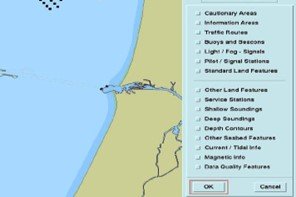
The Graphical Chart
The chart area is the essential part of the display. It allows fast situational awareness by showing the selected sea area as well as other chart-related information such as own ship’s symbol at the current position, the planned and past track, cursor position, scale in use, over scale indication, wheel over point, cross-track limits etc.
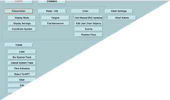
Main Menu
The Main menu contains the top-level functional option such as “chart,” “planning,” “Monitoring” etc. The sub-menus vary according to the selected higher-level function. It is possible to set such parameters as type of chart data, depth contour, type of symbology etc. In the planning mode it is possible to create, modify and check route. Safety limits and past track can be also set. With some systems the menu area can be used as the main “data display” or “conning display” which can be removed to enlarge the chart area.
This menu and sub-menu might differ from ECDIS manufacturer to manufacturer.
Information and Function Bar
The status bar (top horizontal bar) contains the actual navigational data (position, course and speed of own, time, display setting etc).

The function bars (bottom horizontal bar) offers a quick access to some important operational functions (e.g Variable Range Marker (VRM), Electronic Bearing Line (EBL), quick access to standard display, set centre, brightness, Menu and Menu tree).

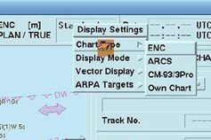
Select the Chart Type via the Display Setting
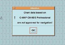
If the chart type is not an approved type an alarm will appear on the screen.
Operational Elements
- Buttons on the screen are used to switch various functions on and off, and to make the menu choice
- The keyboard for the manual entry of alpha-numerical information into the system may be a real keyboard
- A roller ball or a mouse is used to call up function and information, to shift the chart, etc
4. BASIC SETTINGS OF ELECTRONIC CHARTS
The ability to choose the amount of navigational data to be displayed for the current situation is one of the most important advantages of an Electronic chart system compared with paper chart.
Navigational objects are to be added to, or removed from the display chart.
According to IMO “Performance standards for ECDIS” there are 3 levels of display category:
Display Base
This presents the minimum set of information which is always displayed and cannot be removed from the screen. This shows only the most important objects like coast line, own vessel safety contour as defined by the officer, isolated danger which is less than the safety contour which lie within the safe waters as defined by the safety contour, TSS, etc. This information is not sufficient for safe Navigation.
Standard Display
The standard display must contain at least the “Display base,” in addition other features as zero-meter contour, fairway limits, conspicuous objects, special areas, prohibited and restricted areas etc. The scope of the information can be changed by the Watch officer. This mode is most appropriate for the ECDIS display for navigation.
All Other Information
All other information can be displayed on demand. This category includes objects like spot sounding, underwater cable routes, details of navigational aid, details of isolated dangers etc. It is easy to overload this display with objects.
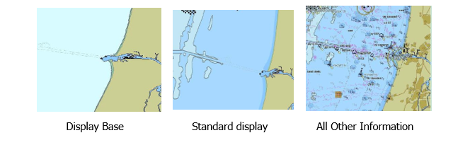
| Display Base | Standard Display | All Other Information |
|---|---|---|
| Minimum set always displayed | Includes Display Base + additional features | Optional detailed objects |
5. CHART HANDLING
Choice of Sea Areas
The immediate sea area around the own-ship current position is normally displayed during route monitoring. When the vessel is moving in an ENC based electronic chart, the chart area being displayed is adjusted automatically. For convenience, several charts can be loaded in advance.
Selecting Chart of Any Other Sea Areas
In order to call up manually and display any sea area which does not contain own ship's position e.g. for route planning, various manufacturers use various procedures:
- A world chart or globe which the user may zoom-in and centre for the desired sea area,
- A list of names (place, port) from which the user may select the desired sea area,
- A geographic position
Cells can be selected by selecting the drop-down box from the “Navigational purpose” box.
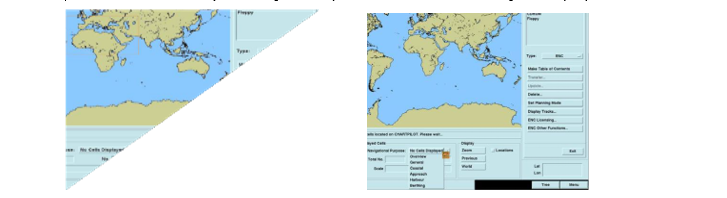
For raster charts, normally a list of available charts is presented to the user and he may select the chart from the list.
Areas of Which Special Conditions Exist
The following are the areas which ECDIS can raise an indication or an Alarm if the ship is within a certain area or within a pre-set distance or time from a given area. These are not limited to the below only and few are mentioned:
- TSS, Traffic routing system, Crossing or roundabouts, precautionary areas, 2 way route, deep water route, fairway, restricted area, caution area, Areas to be avoided, Ice area, fishing ground, channel, fishing prohibited, pipeline area, cable area, anchorage area, anchorage prohibited, dumping ground, spoil ground, dredged area, etc.
This function is not available when the electronic chart system is using Raster charts.
Detailed Background Information
In normal circumstances, the display is freed from information that is not needed. In some cases this information is available as a background information source. The officer may point to a position with the cursor in order to acquire further information. When this object is picked all pertaining information about this object is shown on demand in the Information window. This depending upon the manufacturer is called “Info Box” or “pick report”.
The information window provides detailed information on selected objects and the following info is available:
- What type of light or buoy it is or sailing route in case of a channel?
- Depth at the location?
- Details of the buoy can be obtained
- Information of the Radar in range for the port
- Information on the sea area
- What is the VHF to be used etc
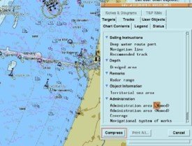
Typical ECDIS “info box” for a Navigational object: The info box is for a position as selected and the card shows – Chart content > visible Navigational mark > Buoy Cardinal to select the buoy and the actual information window with the details of the buoy including e.g. identification, position, shape, category, colour, light characteristics, and source indication.
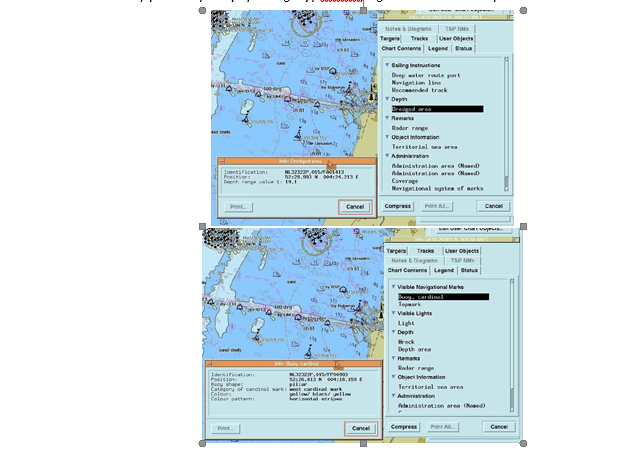
Beside object-related information, this report may also provide information about operational matters like Pilot related information, pilot boarding position, and communication channels.
These reports enable the watch officer to find out the duties of his ship; in principle this report takes over the role of the other special nautical publications such as list of lights, sailing direction and the VTS guide. This window is normally placed in an area on the screen where it does not obscure the selected feature or the main chart area.
6. NAVIGATIONAL TOOL
The ECDIS is not only a graphic display but also a “Work Station”. In addition to the automatic navigational functions, it provides the tool to perform the conventional functions performed on paper charts (Chart work). The conventional procedures such as:
- Fixing own ship's position on the chart;
- Drawing of bearing lines and distance rings;
- Laying down the intended chart course;
- Manual entering of notes etc
that the mariner does on the chart can also be accomplished on the equivalent electronic chart as well. The functions used on an electronic chart include way-point, EBL, VRM, distance rings, cursor, reference point, lines of position, position fix, Mariner notes and dangers highlight.
The Mariner needs to be able to demonstrate that the minimum marking as required to be done on the paper chart is also completed on the Electronic chart.
Conventional Functions
ECDIS employs computer-based tools (e.g. cursor) rather than a parallel ruler and pair of compass dividers to deal with bearing and distances, for example:
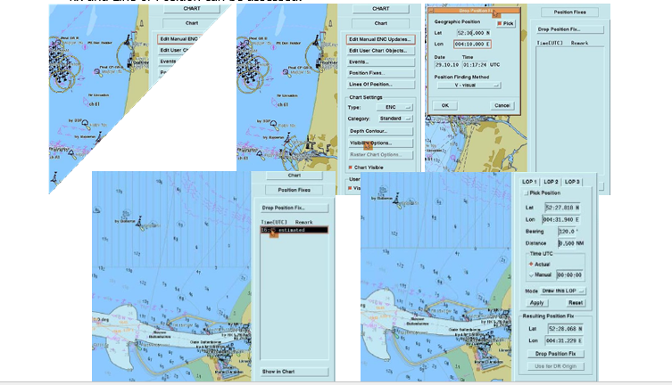
Line of position (LOP) can be drawn on the screen both as a circle around the reference object (distance determination) and as a straight line through the reference object (bearing determination).
Own ship can be marked with a “position fix” function i.e. when the fix as per the passage plan is required to be done manually.
The position of the cursor can be used to determine distance and bearing between two points (e.g. from the vessel to the reference point or between any two target points).
Below figure demonstrates that these are available through the chart Menu, where the Position fix and Line of Position can be assessed:
Mariner’s Note and Danger Highlights
The note function can be used to enter text, symbols, and simple graphics like lines and areas can be entered manually into the electronic chart display in order to events or to make notes requiring attention. Once done the officer can modify these accordingly. The following options are available:
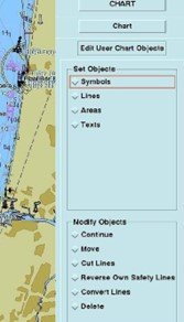
- Symbols: Pre-defined symbols are provided to make various notes, the officer can select symbol or and set the symbol by position. The officer can select Anchorage area, Beacon, buoy, light vessel, light float etc.
- Lines: These can be drawn with the help of track ball. The officer can draw his own safety line, Feature line and MARPOL lines. The line pattern can be selected as below with the Object name and Users remark for this to be reflected on the chart.
- Areas: These can be drawn with the help of track ball. The officer can highlight the danger area and mark it in red colour by selecting “Danger Highlight”. Feature area and anchor watch area can also be selected by the officer. Anchor area can be as a polygon, circle or zone.
- Text: Typical examples include “Wheel over position”, “Call Pilot” or the famous “CALL MASTER” can be marked on the chart. When selecting the note the officer can categorize the note as an “Information” or “Caution” and the appropriate Remark can be entered by the officer.
7. ROUTE PLANNING FUNCTION
Planning a route is a requirement to safely navigate the vessel from Point A to B. This can be easily done on the electronic chart. The first is to display the area intended for the Route at a desired scale, the route plan is then created by entering waypoints graphically than alpha-numerically. After the entire route is created, it should be displayed and safety-checked and finally saved for later implementation in the ECDIS as a route plan.
These waypoints and route can be saved in the route library and reused in future.
Graphical Route Planning
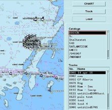
The route plan can be selected and loaded on the ECDIS from previously saved plans via the menu button:
When preparing a new Route plan this can be done via the Menu and the help of the Cursor. Cursor can be used to create waypoints which are then connected to create a Route. This selected route can be changed by moving, editing or inserting waypoints. Different manufacturers follow different procedures.
Waypoint Data and Waypoint List
Beside the position, individual waypoints of the route are given a “waypoint data”: an Identification no and depending upon the setting can also give the turning radius and alert time before wheel over.
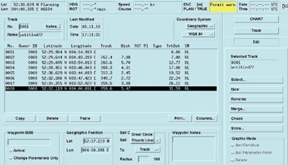
Similarly, the legs are given “leg data” on the planned speed, the maximum crossing track limits and whether the voyage takes place on a Great circle or rhumb line route. The above / below figures show a typical waypoint list of the selected route with waypoint data, calculated distance, course between waypoints and other information. The waypoints can also be modified from this list by using the alpha-numerical editing mode.
Route Monitoring Functions
Electronic charts contain a wide range of functions for monitoring the ship's voyage. On the ECDIS, effective visual route monitoring can be performed:
- By presenting the sea area in the most appropriate scale.
- By adapting the contents of the displayed chart to the actual situation (ship's draught, day and night, etc).
- By look ahead function
- By track related alarms
Ship's Real-Time Function
Electronic charts have an important advantage in that they show continuously and automatically the actual position of the ship in real time. This enables the watch officer to easily check if the ship is following the planned route or if it is approaching a dangerous object. In comparison, position plotted on a paper chart only shows where the vessel was some time ago, and not in its current position as on the ECDIS display. The ECDIS requires that the position fixing system is working properly.
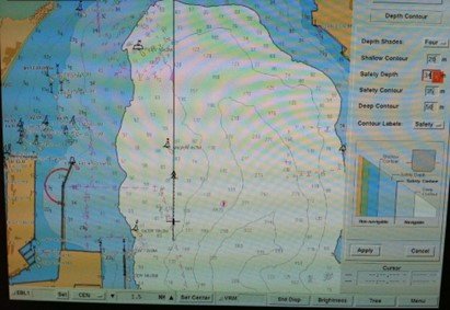
Below figure displays the position, motion vector of own ship in real time as well as relevant buoys, cardinal buoys, SBM restricted area, anchorage area and prohibited anchorage area etc. This all will clearly indicate the vessel is on the right track.
Planned Route and Past Track
The monitoring of own ship's motion can easily be performed by checking:
- The planned track – is the current position on or close to the planned track
- The Past track of own ship – has own ship so far proceeded on track
In particular, the past track provides an excellent and powerful criterion for judging the reliability of own ship's position at any time. The past track is shown as a black thick line that can also contain time markings.
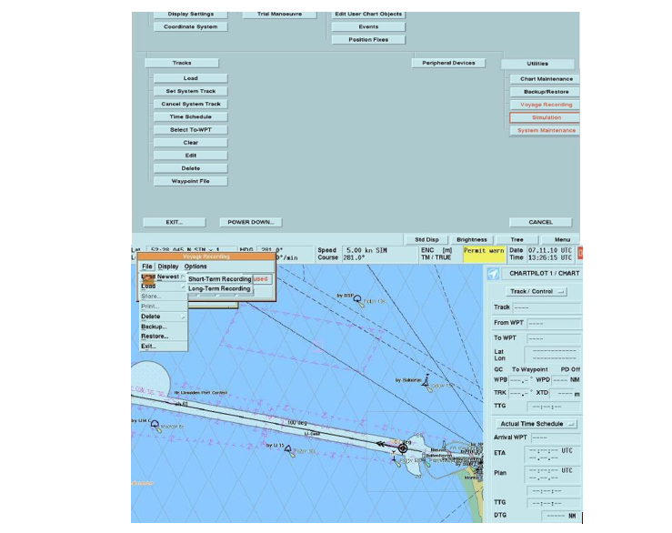
ECDIS Voyage Recording
Using ECDIS, a record of the voyage is required as it is for the paper chart. The voyage record must be suitable to reconstruct the voyage and may be used for an accident investigation purpose or for future voyages on the same route. As a minimum the following information is recorded:
- Short term recording – for 12 hours of intervals not more than 1 hour
- Time, position, course and speed of the ship to be able to reconstruct the past history of the ship’s motion
- Source, edition no, date, cell and update version of the ENC in use in order to ascertain which charts were actually displayed
- Long term record – for the entire voyage at intervals of not more than 24 hrs
- The past position of the ship to enable course reconstruction of the entire voyage
8. ADMIRALTY INFORMATION OVERLAY (AIO)
The AIO is an optional additional overlay that can be turned on and off within ECDIS independently of the display of ENC data and is intended to support passage planning and demonstration of compliance. It has three features:
- EPNMs (Electronic Preliminary Notice to Mariner) - to help the mariner resolve problems (inconsistencies) they may face using ENCs and ADMIRALTY paper charts;
- T&P information – to show the mariner where T&P notices apply to ENCs;
- No Overlay – to show where the UKHO is unable to provide either EPNMs or T&P information;
AIO is an S-57 based data set that uses ‘private extensions’ to the object catalogue to describe the features and attributes. AIO features are shown as simple polygons drawn on top of the ENC data with the identifier encoded in the OBJNAM attribute and a description in the INFORM attribute. Where necessary text and picture files are included to provide further detail.
Not all ENC producers include Temporary and Preliminary (T&P) Notices in their ENCs.
A list of the latest available information from each ENC producer is available on the UKHO website and can be made available if required from the shore office.
In case the vessel is calling a port in the country where Temporary and Preliminary (T&P) Notices are not included in the ENC’s, a request for Admiralty Notices to Mariners (NM) for the present year must be made from the authorized digital service provider.
The publication ‘Annual Summary of Notices to Mariners’ must be referred to additionally to ensure all the T & P’s in force are appropriately marked on the ENC.
9. MARINE INFORMATION OBJECTS (MIO)
MIOs are separate, supplementary information that are displayed in conjunction with the overall System ENC and are not contained within nor are they an integral part of an ENC.
They are similar in concept to adding radar and AIS information to an ECDIS display.
Examples are Tides / water levels, Ice coverage, Meteorological, Oceanographic, Marine Habitats, Environmental Protection, Archaeological, Vessel Traffic Services (VTS), and Aids to Navigation Status etc.