| FOM-3.29 |
Fleet Operations Manual Navigation ECDIS |
Doc No.: FOM-3.29
Revision: 01 Date: 15 Oct 2024 Issued by: DPA Approved by: MD |
1. Application
- This document applies to Masters, navigating officers, and watch keepers onboard fully managed vessels.
- For Company’s vessels, equipped with approved Electronic Chart Display and Information System (ECDIS) and meet the carriage requirements for ECDIS as a primary means of navigation in accordance with SOLAS, Reg.V/19.2.1.4 – V/19.2.1.5, the Electronic Nautical Charts must be considered as the Primary Navigational Charts System, further identified in their individual SEQ form E.
2. Purpose
To specify requirements for ECDIS, identify the responsibilities and methods for ECDIS training, familiarization, operation, and monitoring standards.
3. Responsibilities
Master and OOW shall:
- Promote effective and safe bridge resource management to include ECDIS.
- Manage situational awareness with ECDIS.
- Be able to revert to ECDIS backup system whilst maintaining safety of navigation.
- Familiarize with the onboard ECDIS.
- Monitor ECDIS alarms and sensors.
- Monitor all system inputs and cross-check data sources.
- Comply with standing and daily orders for ECDIS.
4. Electronic Charts – Operational Information
Note: For definitions, main components, technical details, basic functions, and settings involving ECDIS, see FOM 3.24 – Definitions and technical details of ECDIS.
4.1 Types of Electronic Charts
Information: There are two types of electronic charts:
- Raster Chart - which is a scanned and passive image of a paper chart.
- Vector Chart - which corresponds to digital analysis by object (points, lines, areas, etc.).
Official electronic chart data are of two general types:
- ENC - Electronic Navigational Charts.
- RNC - Raster Navigational Charts.
The inner construction of ENCs and RNCs is fundamentally different:
- ENCs are vector charts, and
- RNCs are raster charts.
Caution: The term “Official” indicates that those chart data have been produced under the authority of a government organization – in contrast to private, i.e., non-official electronic chart data which might be technically of the same type but have been produced without government authority.
For detailed information on the above types of charts, see FOM 3.25 – Types of electronic charts - Additional information.
4.2 Quality of the Hydrographic Data
Information: An ENC is an auxiliary navigation aid, while an ECDIS is a navigational system.
Caution: The reliability of the data – including how complete, how accurate, and how current – can have a significant impact on the safety provided by the overall system.
The quality of the data used in an electronic chart depends upon several factors:
- The details and accuracy of the hydrographic survey data.
- Source(s) used for data production.
- Frequency of updating the database.
- Quality assurance procedures applied during production.
4.3 Use of ECDIS in RNC Mode
Information: ECDIS is capable of operating with both:
- RNC - Raster Navigational Charts.
- ENC - Electronic Navigational Charts.
Caution: When used in the Raster Chart Display System mode (RCDS), use the system in conjunction with an appropriate portfolio of up-to-date paper charts.
Caution: For detailed information on the types of charts and risk assessment guidelines, see FOM 3.25 – Types of electronic charts - Additional information.
4.4 ECDIS Backup
When a vessel is fitted with 2 sets of independent ECDIS complying with IMO standards, the Master shall ensure the following procedures apply:
- Regard one of the two ECDIS as primary (Master) while the other as secondary (Slave).
Note: Clearly identify these by appropriate labels & record in file.
- Make the passage plan available on both ECDIS at all times.
Note: “Slave” ECDIS can be on stand-by mode during voyage execution.
4.5 Acceptance ECDIS by Port State Control
Information: Checks may include:
- Ship has documentation indicating that the system complies with IMO Performance Standards for ECDIS.
- Whether ECDIS is used in the ENC mode or RCDS mode or in both modes.
- Written procedures onboard the vessel for using ECDIS.
- Master and watch-keeping Officers generic and type-specific ECDIS familiarization.
- Charts used for the intended voyage are the latest official editions.
- Charts in use are updated.
- Approved back-up arrangements available to ensure:
- a safe transfer of the ECDIS functions in the event of ECDIS failure and
- to provide safe navigation for the remaining part of the voyage.
Caution: Masters should verify that the above conditions are met. Contact Marine Superintendent for any clarifications or non-compliance related to the same.
4.6 Limitations of ECDIS
Warning: Do not totally rely on ECDIS. Over-confidence can result from the fact that ship’s position is automatically shown on a chart. ECDIS is only a tool that helps a mariner safely and effectively navigate a ship. It is not the end-all be-all to ship navigation.
Note: The OOW must always be wary as to how the system is actually performing in regard to accuracy and reliability. This requires an awareness of the deficiencies and risks of the overall system and its components.
Master/OOW shall consider the following factors when using ECDIS:
- Technical limitation of devices:
- Potential risk of improper functioning of the system.
- System limitations, including those of its sensors.
- Potential errors in the display of:
- The own ship's position.
- Radar data and ARPA information.
- Different geodetic co-ordinate systems.
- Radar data representation on an electronic chart - Discrepancy between radar image and the electronic chart.
- Chart accuracy:
- Hydrographic data inaccuracy; limitations of vector and raster electronic charts (ECDIS vs. RCDS and ENC vs. RNC).
- Possible projection discrepancies between an electronic and paper charts.
- Errors in manual or automatic data correction.
- Familiarization of ECDIS:
- Potential risk of human errors.
- Knowledge of principal types of ARPA/ECDIS/AIS, their display characteristics, performance standards, and the dangers of over-reliance on ARPA/ECDIS/AIS.
- Using the best-suited sensor to the given situation and circumstances.
- Over-reliance on the automated features of the integrated bridge system.
- False interpretation of the data:
- Ignoring under or over scaling of the display.
- Uncritical acceptance of the own ship's position.
- Confusion of display mode.
- Confusion of reference systems for positioning.
- Different modes of presentation.
- Different modes of vector stabilization.
- Differences between true north and gyro north (radar).
- The same data reference system.
- Entering the correct values of safety data - Safety Contour, Safety Depth.
- Effects of the motion of the ship in a seaway.
- Different horizontal and vertical datums.
Caution: Keep a proper look-out and perform periodical checking, especially of the ship’s position by ECDIS-independent methods.
5. Safety Considerations While Using ECDIS
5.1 Contours and Depths
Following safety settings related to the charted depth are applied on the ECDIS:
- Safety depth.
- Safety contour.
- Shallow contour.
- Deep contour.
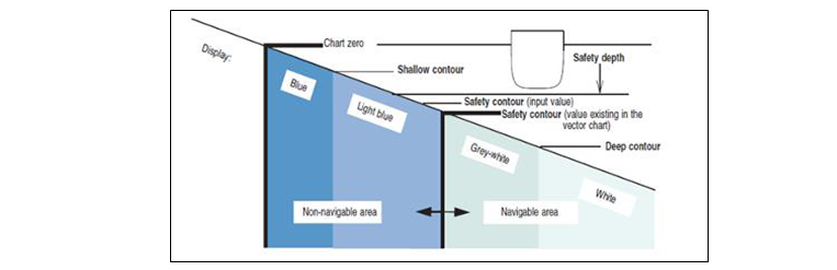
White & White grey: Navigable Waters
Dark Blue & Light Blue: Non – Navigable waters
The safety depth:
- It is considered the minimum charted depth required in which the vessel can safely navigate.
- It is a value set by the navigator that is used by ECDIS to indicate soundings as:
- Black - if they are equal to or smaller than the value, and
- Gray - if they are deeper.
Note: Safety depth the resulting value must be rounded up to the nearest higher whole number e.g. 23.3m rounded up to 24m.
It is a value calculated as per below.
Calculations -
Safety Depth = Vessel Draft + Dynamic Squat + UKC + Safety Margin - Tide Height
| Deepest Navigational Draft (Static) | 10.0 m |
|---|---|
| Squat for transit speed (Form 002) | + 3.5 m |
| UKC (as per FOM 3.33) | + 1.0 m |
| Sea/Swell allowance (If any) | + 0.0 m |
| Bottom pipelines if present (Allow 0.7m) | + 0.0 m |
| Controlling Depth | 14.5 m |
| Height of Tide (HOT) | − 0.0 m |
| Safety Depth | 14.5 m |
Note: “Safety margin: It refers to environmental and other factors, like sea / swell, Heel / List, change in density (DWA / FWA), Hog / Sag, and any other factor as guided in FOM 3.33 Section 6 which can lead to increase in draft.”
The safety contour:
- denotes the boundary between the navigable & non-navigable waters and
- is used to give an alarm if the ship, within a time specified by the Navigator, is going to cross the safety contour.
- it generates warnings against planned and monitored route.
- is highlighted on the ENC chart with a bold line.
Note: It is important because this value will form the basis of chart monitoring.
Caution: Safety contour should be set as a value equal to the safety depth.
Shallow Contour:
- Shades the area from the shallow contour to zero depth.
- Setting:
- Should be the value closest to but not less than vessel’s draft.
- May be considered the grounding line.
Note: This acts as a warning to the vessel in case of a breach of minimum depth contour in line with the company policy.
Deep Contour:
- Shades the area below the deep contour (above is white).
- Should be set as twice the dynamic draft (Max. static draft + Squat).
ECDIS Safety Parameters Setting - Summary:
- Shallow contour: Next contour shallower than safety contour/must not be less than vessel’s draft.
- Safety depth: Vessel draft + dynamic squat + UKC + safety margin - tide height.
- Safety contour: Safety contour should be set at a value equal to the safety depth.
- Deep contour: Twice the vessel’s draft.
Note: If all Contours are correctly configured, the following depth information is shaded and distinguishable from each other:
- Zero to shallow contour (dark blue).
- Shallow contour to safety contour (light blue).
- Safety contour to deep contour (light grey).
- Greater than deep contour (white).
- Zero to safety contour (blue).
- Greater than safety contour (white).
5.2 Crossing the Safety Contour
Information:
- Due to limitation of ECDIS not showing the contour line of desired depth, ECDIS cannot make a contour line of selected Safety Depth.
- Instead, it will automatically shift to the higher contour line available on the chart.
- Due to this, it is highly likely that at points within the voyage plan, the vessel will need to navigate in waters inside (shoaler than) the highlighted safety contour.
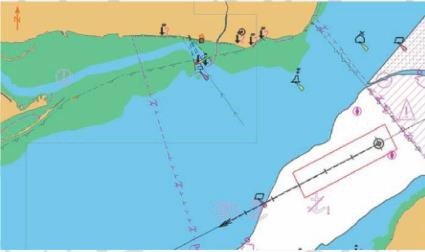
There are multiple methods that may be employed to cross the displayed safety contour to minimise the impact on safe navigation.
Vessels under Management shall adopt the procedure as defined below:
Instructions: Configuring the ECDIS to cross the Safety Contour
- Calculate the safety depth and enter into ECDIS.
- Select Safety Contour in ECDIS as per section 5.1.
- Select viewing groups for soundings, seabed features, and contours to be displayed. Ensure all obstructions and potential hazards are displayed (Safest is to use Display “ALL”.
Note: The entered safety depth will indicate all soundings which are equal to or less than the safety depth in black text. All soundings greater than the safety depth will appear as grey text.
- Visually assess the area within the safety contour to identify areas greater than the safety depth to determine that planned leg remains in safe water.
- Mark ”No Go” areas by joining depths below safety depth using navigation editor tools like LDL (Limiting Danger Line) and add notes to the passage plan to make sure this area is identified during the approval and briefing stages and visible to the OOW.
- Add Mariner’s note to show area that may be crossed at appropriate height of tide with time and date for planned crossing.
- Run route check to confirm that safety contour crossing is identified and note in Voyage Plan for review and approval by the master.
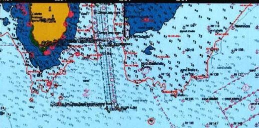
Hazards associated with this method: Master/navigating officers shall pay caution to following hazards associated with this method:
- Automated route check will display a warning for crossing the safety Contour but possibly no further indication if the route is planned into waters shallower than the entered Safety Contour.
- Similarly, during monitoring of the voyage, the guard zone will activate an audible alarm when it encounters the safety Contour and possibly not activate any further alarms once vessel moves into water that is shallower than the entered Safety Contour.
- A danger could be missed during the visual inspection of the ENC with no electronic warnings or alarms to warn the user.
- As the safety contour alarm will be activated but disregarded, a culture of “the safety contour doesn’t really matter” may develop and lead to the safety contour indication during planning or alarm monitoring, being dismissed as not important at any time.
5.3 Accuracy of ENC Data or Zone of Confidence (CATZOC)
Information:
- The function which allows accuracy of the survey data to be displayed for each ENC cell is called 'Category of Zone of Confidence' (CATZOC).
- See table below for CATZOC categories- ranging from A1 (most precise) to U (unassessed).
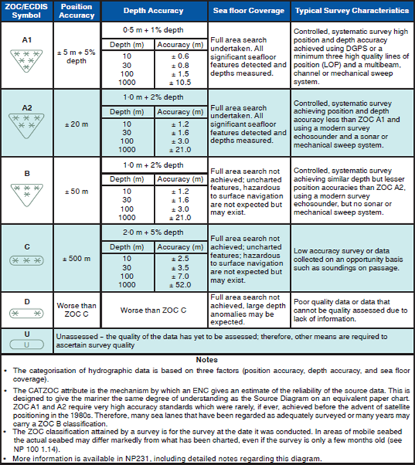
Note: Print this table & post it close to the ECDIS planning station.
Instructions:
- OOW shall apply CATZOC corrections when carrying out UKC calculations.
Note: Refer to FOM 3.33 for UKC calculation procedure for CATZOC consideration.
CATZOC Categories Table: (Table not provided in text; add details if available.)
5.4 Alarm Management
Automated ECDIS alarms may become excessive and, in some cases, can lead to “alarm fatigue” where OOW are unable to properly investigate routine alarms whilst maintaining other essential tasks. This is normally due to a combination of:
- The configuration of the ECDIS safety settings, e.g., Look-ahead.
- The position of the vessel itself (i.e., in close quarters situation, crossing traffic lanes, or close proximity to land).
- Some ENC producers may chart features with attributes that will trigger alarms across a wider spectrum and for large areas of the ENC e.g., caution areas.
Configure ECDIS as following to avoid excessive alarms:
- Only with alarms required for the safety of navigation for each navigation sector.
- Do not replicate alarms generated on other systems e.g., ARPA.
- Master shall disable any unimportant navigation alarms that do not affect the safe navigation of the vessel.
Caution: System alarms must never be inhibited, muted, or overridden. These are termed “basic safety parameters and alarms”.
The following are basic safety parameters and alarms:
- Safety contour.
- Safety Depth.
- Safety Scale.
- Position system failure (WGS 84 datum).
- Chart Display Category.
- Chart priority.
- CPA/TCPA.
- Cross Track error / XTE.
- Course difference.
- Waypoint approach.
- Safety Vector.
- Area Vector.
- Safety frame.
- Navigation danger ring (its Radius).
- Special Area detecting (defined yes) Mandatory Alarm and indicators as per IMO – 867E.
These alarms on ECDIS and connected RADAR are the bare minimum for Navigation safety and overriding is not allowed under any circumstances.
Instructions:
- Inform relieving OOW, Master, and Pilot if any alarms or indicators have been received, muted, or overridden.
- Configure ECDIS to sound audible alarms from the central conning display if integrated bridge system (IBS) is fitted.
- If ECDIS is not part of IBS and if fitted with 2 ECDIS:
- Configure 1st unit for visual and audible alarms.
- Configure 2nd unit for visual alarms only.
- If ECDIS is not part of IBS and if fitted with 1 ECIDS:
- Configure the unit for both visual and audible alarms.
Note: Regardless of arrangement, the system must be configured to ensure that the same ECDIS alarm does not sound audibly from more than one source. Do not rely solely on automated monitoring alarms generated by the ECDIS. Reconciliation between the view from the bridge and the vessel position with respect to charted features shall be maintained including a check that the sensors are providing an accurate fix of the vessel position.
Caution: It is extremely important that alarms, both audible and visual, be investigated before acknowledging and resetting. During change of watch, it is important that the relieving officer familiarizes himself with all the alarms that are active and assures himself that each of the alarms has been acted upon by the officer being relieved or otherwise poses no danger to the vessel’s navigation.
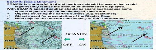
5.5 Display Scales and SCAMIN
Scale Minimum (SCAMIN):
- Is the minimum (smallest) scale at which the features within the ENC can be displayed in an ECDIS.
- Is used to significantly reduce the amount of information on the ECDIS display when reducing the viewing scale of an ENC.
Instructions:
- Use the ENC as near as possible the compilation scale, when appropriate scale ENCs are available, during voyage monitoring.
Note: When the OOW zooms out to improve situational awareness, the ECDIS may indicate an under-scale warning and may limit this operation to a certain scale factor. The OOW must be conversant with the procedure for resetting to the ENC compilation scale as soon as wider situational awareness has been established.
- Use smaller scale charts to manipulate waypoints during the planning stage.
- Manually check the route for dangers at compilation scale.
Scale Minimum (SCAMIN):
SCAMIN must be selected OFF for appraisal, planning, and review phases to ensure all information is seen.
SCAMIN may be temporarily selected ON, only for execution and monitoring of the voyage plan, based on master evaluation, with the purpose to reduce the effects of an over-crowded display.
Note: The OOW must make sure that compilation scale, otherwise known as 1:1 scale, is used during passage execution and monitoring and that navigational decisions are not made on an over-scaled ENC.
Look-ahead ENC Related Alarms
Information:
The “Look Ahead” function provides the user with an advance warning of dangers/cautions and may be used as an anti-grounding function.
- For this purpose, a monitoring zone moves with the ship and raises an alarm if the ship is to:
- Cross a safety contour;
- Cross the boundary of a prohibited area or of an area for which special conditions exist;
- Pass too close to an ENC object, i.e., buoy or an oil rig, within a look-ahead time pre-set by the watch officer.
- User only needs to define the area in which he needs the ECDIS warning as below:
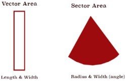
- Vector area (defines the area in length and width).
- Sector area (defines the area in radius and width angle).
Instructions:
- OOW shall adjust settings considering prevailing circumstances:
- Traffic density.
- Present speed.
- Proximity of navigational hazards.
- Stopping distance of the vessel.
- Master must make reference of this setting in his standing orders mainly for open seas, coastal/pilotage waters.
Caution: Check and verify this setting prior to taking over the watch. Refer to NAV-11A ECDIS Change Over Watch Checklist.
Recommended Configuration:
| Danger Detection Vector Area | Open Navigation | Coastal Navigation | Restricted Navigation |
|---|---|---|---|
| Vector Length (min) | 30 | 12 | 3* |
| Vector Width (m) | 250 | 200 | 100* |
| Danger Detection Vector Area | Open Navigation | Coastal Navigation | Restricted Navigation |
|---|---|---|---|
| Sector Radius (min) | 30 | 12 | 3** |
| Sector Width | 60° | 45° | 30° |
* During the transit of a narrow channel or fairway, the vector width might need to be adjusted to ensure that the danger area alarm is not continuously activated while the vessel is being safely navigated.
** During the transit of a narrow channel or fairway, the sector radius and sector width might need to be adjusted to ensure that the Dangerous Object Alarm is not being continuously activated while the vessel is being safely navigated.
Note: The above setting is a recommendation/guidance only and can be amended by the Master depending on external factors. The navigation and anti-collision alarms must be set at the commencement of the voyage, and no one other than the Master has the authority for adjusting or altering the set points. If a duty officer deems it necessary to change any alarm setting, he should bring it to the notice of the Master.
Caution: Grounding alarms will not activate unless safety contours are correctly set.
Note: Look ahead can contribute to an excessive number of alarms on ECDIS when navigating in restricted waters or curved channels. As a preventive action against fatigue caused by ECDIS alarms, the company allows modification of look-ahead volume below requirements; however, such adjustment must still secure sufficient time for immediate danger avoidance.
5.6 Route Check and Route Correction
Information:
- This function checks the route for navigational risk.
- ECDIS compares:
- Features of all relevant objects along the planned route as a potential risk, with
- data required for own ships safe navigation.
- If this reveals dangerous objects which exceed the set safety criteria, it will provide a warning.
- The internal route check is conducted independently of the actual scale used.
- This may be a message window containing a list of the relevant objects verifying that the planned route does, for example:
- Cross a shallow “depth contour.
- Transit less than a chosen safety distance from a buoy or obstruction or an area.
- Cross limits of an area where special conditions exist, e.g., fishing prohibited area.
Instructions: Master/navigating officers shall:
- After the visual inspection of the route in various scales and before departure, check the selected route using this function.
- Set limits for “safety values”, planned speed, and way-point radius.
- Use the largest scale of chart because discovered infringements may not be displayed otherwise.
Caution: Make corrections to the route until all foreseeable dangers are avoided.
Note: Only object-based vector data can recognize the danger along the route, RCDS data cannot.
5.7 Cross Track Distance (CTD) & Display Layers
The set CTD values are of critical importance. If these values are too small, and if the vessel needs to deviate from its route, dangers near the route but outside the CTD will not be highlighted. If these values are too large, a substantial number of alerts might be generated.
| Scenario | Standard Display plus additional layers** | Other considerations |
|---|---|---|
| Open Waters | Spot soundings to a depth of 2000m Details of isolated dangers Show Correction |
Recommended CTD 3 nm |
| Coastal Water | Spot Soundings to a depth of 100m Details of isolated dangers Ferry routes Details of aids to navigation Contents of cautionary notes |
Recommended CTD 0.5 nm |
| Confined Waters/ Buoyed Channel/ Anchoring | Spot Soundings to a depth at least equal to the value of the Safety Details of isolated dangers Submarine cables and pipelines Contents of cautionary notes Tides and Currents Seabed |
Recommended CTD 0.1 nm* |
| TSS/Two-way route | Spot Soundings to a depth at least equal to the value of the Safety Details of isolated dangers Submarine cables and pipelines Contents of cautionary notes Tides and Currents Seabed |
Recommended CTD 0.25 nm* |
* Within confined waters and channels, the CTD should ideally be wide enough to cover the maximum width of available water for safe navigation, so the vessel can navigate within the CTD with confidence and without needing to exit the validated corridor. Company recommends above settings. However, master can use his discretion on the most optimum value as per his judgement based on available width of navigable waters.
**If a vessel is expected to leave the originally defined corridor, all layers should be switched on to highlight any information that may be useful to the Navigating Officers. Navigating Officers should call the Master if the vessel needs to exit the CTD.
6. ECDIS Passage Planning
Note: For Passage Planning Guidance and Instructions applicable for all ships (with or without ECDIS), see FOM 3.6 Passage planning.
Prior to using ECDIS for appraisal and passage planning, the navigating officer(s) shall carry out the following:
- ECDIS is operated in International Hydrographic Office (IHO) “All” or “Other” display mode for voyage appraisal, planning, execution, and monitoring when using ENC, IHO base layer is not used for navigation.
- Display of soundings and all underwater dangers, including wrecks, obstructions, cables, pipelines, and foul areas, is enabled during the planning phase.
- Enter vessel’s controlling operational parameters (maximum draft, air draft, turning data, minimum UKC required, look ahead distance, etc.).
- Set GPS position system input to WGS 84 datum.
- Ensure:
- Alarm functions of the ECDIS are fully operational.
- Electronic chart coverage for the voyage is adequate.
- Electronic charts are fully corrected for the intended voyage.
- Mark and highlight electronic charts in a similar way to paper charts.
Note: Such marking should identify radar conspicuous targets, no-go areas, parallel index lines, transit marks, clearing bearings, etc.
- Mark estimated position on the chart for each watch, in advance.
Note: Navigating officer shall set various parameters for each waypoint, i.e., Profile speed, planned speed, course limits, track limit, radius for the ROT.
Caution: Exercise extreme caution whenever information layers are removed, or information level is reduced from an ENC. Master must review this and advise all members of the Bridge Team whenever such changes are carried out.
7. ECDIS Corrections
7.1 Updating and Correction of Electronic Charts
Note: Designated Navigating officer shall be responsible for ensuring ECDIS charts are maintained fully corrected at all times, using the latest Notices to Mariners. Master shall verify the ECDIS update records at least once a month.
- Charts can be corrected by:
- Weekly updates received via email or by
- Update CDs received at regular intervals.
- Where correction data is received electronically through electronic chart correction systems, use this for updating the ECDIS whenever a new correction is received.
Note: The procedure for updating will vary with the manufacturer and the provider of the electronic charts. See manufacturer’s manual for details.
Caution: If weekly updates have not been received from the provider directly via communication computer or through CD/ROM, master must immediately contact Marine Superintendent.
Navigating officer shall:
- Maintain a database of all the ENCs and their corresponding expiry dates of the permits / licenses in the Chart Management System.
- Keep custody and inventory of all base CDs and update CDs for the ECDIS and hand over to his reliever during handing over process.
- Ensure ECDIS updates are necessarily carried out prior commencement of the voyage (if applicable).
- Vessels should only use a dedicated memory stick for transferring latest updates to ECDIS.
- There is still the possibility of virus attacks, therefore updates shall be applied to one ECDIS Console and updating of the second ECDIS should not be done unless the update results are verified on first ECDIS.
- It is suggested to update the back-up ECDIS first. Once it is successful, primary ECDIS shall be updated.
- While updating the ECDIS at sea / during the voyage, both the ECDIS should be decoupled & updated one by one starting with backup ECDIS first followed by Master ECDIS.
Caution: Both the ECDISs should not be updated simultaneously at any given time. Decoupling of ECDIS for updating it at sea / during the voyage should be done in compliance with maker’s instructions.
- NP 133C to be maintained onboard and navigating Officer must print the README.TXT file in the ENC exchange set weekly and insert it into NP 133C.
- The Navigating Officer must make sure that the safety critical information for maintenance of digital products in the Weekly Notices to Mariners Section VIII is applied if applicable to the ENC onboard.
8. ECDIS Certification and Training
For vessels with ECDIS as primary means of navigation, Master shall cross-check that navigating officers possess the following:
- IMO Model course 1.27 (40 hours / 5-day period).
- Type Specific familiarization on actual equipment.
Caution: If shore-based familiarization training cannot be completed, see actions below.
Consider following options prior to the officer taking over the 1st watch:
- Self-familiarisation of equipment using:
- User manual, and
- Company generated and approved checklist.
- Instruction on the vessel by a suitable experienced and able bridge officer.
- Shore staff who have attended the operators course to visit the vessel and conduct onboard type-specific familiarization.
For all vessels, irrespective of type, Master shall cross-check that navigating officers possess the following:
- IMO Model course 1.27 (40 hours / 5-day period).
Note: All Bridge Watch Officers shall complete the ECDIS Familiarization Section in NAV-06 Bridge Familiarisation prior to taking over first watch.
For more information on ECDIS Training, see FOM 3.26 – ECDIS Training - Additional Information.
9. Maintenance of ECDIS
9.1 Software Issues
There are 3 main sources of Software Issues:
- Operating System (OS) issues – Related to updating the operating system of ECDIS.
Note: Original Equipment Manufacturers (OEM) are responsible for this, and software is updated by installing patch files. Marine Superintendent will liaise with OEM to supply the latest version to the vessel.
- Software application issues – Related to the ECDIS software application system caused when OEM have not amended their system to match changes in IHO data.
Note: The Master must check the software version of each ECDIS on board the vessel against the IHO published current versions on a quarterly basis. An up-to-date list of all the relevant IHO standards relating to ECDIS equipment is maintained within the IHO website: http://www.iho.int/mtg_docs/enc/ECDIS-ENC_StdsIn_Force.htm. If the vessel does not have internet, Master to request this info from the Marine Superintendent.
- ECDIS Anomaly - unexpected or unintended behaviour of an ECDIS which may affect the use of the equipment, for example:
- Failure to display a navigational feature correctly.
- Failure to alarm correctly.
9.2 Planned Maintenance
- Designated navigating officer is responsible for ECDIS maintenance as per onboard Planned Maintenance System.
- Following checks shall be included:
- Input Sensors to confirm that performance is satisfactory.
- UPS system (if fitted) to ensure continuous operation of ECDIS in case of power failure.
9.3 Virus Protection of ECDIS
- Where ECDIS units require transfer of data from other dedicated computer (e.g., CHATCO), use dedicated data transfer devices, such as pen drives.
- Pen drive to be labelled as "For ECDIS use only".
- Master must ensure that these devices are:
- Scanned for virus each time prior use.
- Used only for update of ECDIS.
- Not used on any other computer/device.
- No other files, other than ECDIS update files, are stored in these devices.
9.4 ECDIS Data Presentation and Performance Check for Mariners
Note: From 1st September 2017 - Changes are introduced in Edition 4.0 of the IHO ECDIS presentation library. As a result, the ECDIS data presentation and performance checks published in 2011 are not required (which were developed for previous versions).
Master shall ensure:
- An ECDIS type approval certificate is available - showing conformance with tests in Edition 4.0 of IEC 61174.
Note: This demonstrates that: ECDIS operates with Edition 4.0 of the IHO ECDIS Presentation Library and ECDIS does not have any of the identified ENC display anomalies.
ECDIS and the IHO Presentation Library Edition Number:
All Navigating officers shall:
- familiarise themselves with the function in their ECDIS that will display the edition number of the IHO Presentation Library.
See FOM 3.27 - Checking the IHO S-52 Presentation library edition number in the ECDIS
Note: This varies across ECDIS manufactures. This function will be required when Port State Control officers want evidence that the ECDIS is up-to-date to the latest IHO standards.
ECDIS Chart 1 and IHO Presentation Library edition 4.0 checks:
ECDIS users can check that their systems can display the new symbols introduced in the IHO S-52 Presentation Library edition 4.0 by opening the ECDIS chart 1 datasets.
See FOM 3.27 - Checking the IHO S-52 presentation library edition number in the ECDIS
Frequency of Checks:
- Once after installing an ECDIS.
- After a software update, system upgrade, or change of equipment.
Reporting:
Master shall immediately report any discrepancy or negative outcome to:
- Marine Superintendent.
- Provider of the ECDIS.
- IHO at info@iho.int.
10. Failure of ECDIS
Vessels using paper nautical charts as secondary means of navigation shall ensure that they are kept up to date for latest Notice to Mariners and T and P corrections so that passage plan can be prepared and monitored using paper charts.
Vessels with dual ECDIS shall comply with the following sub-sections.
10.1 Failure of Master / Primary ECDIS
- In the event of failure of Master ECDIS – Secondary ECDIS shall take load and perform full functionality.
10.2 Total ECDIS Failure (Master & Slave / Secondary ECDIS)
- Vessels shall refer to FOM 3.28 flow chart.
- Implement contingency measures as per ECP A35 Matrix.
- Ensure immediate notification is carried out to Marine Superintendent or vessel manager or emergency contact as per poster 13 displayed in bridge radio room.
10.3 Sensory Input Failure
Caution: If sensory input to ECDIS fails, the safe navigation of the ship may be affected.
Follow below listed actions:
OOW shall:
- Inform Master.
- Identify the failed sensory input to ECDIS.
- Commence traditional position fixing methods.
Master shall decide/determine:
- If the failed sensory input affects the safe navigation of the ship.
- If additional resources are required (Increase BW level).
- If the failed sensory input affects any other electronic systems.
- If the backup ECDIS can be used.
- If the ship’s passage plan requires to be amended.
Note: Master shall inform Marine Superintendent.
Caution: In case ship staff are unable to rectify/repair the sensory input and the vessel requires proceeding without operational ECDIS, Master shall carry out a detailed Risk Assessment and take approval from office.
11. Reference Forms and Checklists
- NAV Form 002 – UKC Calculation.
12. Appendices
- FOM 3.24 – Definitions and technical details of ECDIS.
- FOM 3.25 – Types of electronic charts - Additional information.
- FOM 3.26 – ECDIS training - Additional information.
- FOM 3.27 – Checking the IHO S-52 presentation library edition number in the ECDIS.
- FOM 3.28 – ECDIS failure flowchart.
- NAV-11A – ECDIS Change over watch.