| FOM-3.34 |
Fleet Operations Manual Navigation Ice Navigation |
Doc No.: FOM-3.34
Revision: 01 Date: 15 Oct 2024 Issued by: DPA Approved by: MD |
1. APPLICATION
This document applies to all vessels managed under Company.
2. PURPOSE
The purpose of this document is to provide general guidance for navigation through ice and icy regions.
3. GENERAL GUIDANCE ON ICE NAVIGATION
3.1 General
In addition to the guidance provided below, all vessels proceeding to Ice region to seek office advice, carry out a detailed Risk Assessment and refer to the relevant section in The Mariners Handbook with special emphasis to Section “Navigation in Ice”.
Ensure that while planning the passage through the ice, routing provided by the coast stations is adhered to. The course-plotting will be mainly based on the conditions of ice in the area. On many occasions the rules of the road as per COLREGS such as a traffic separation scheme may not be applicable due to formation of thick ice on the passage.
Ice is an obstacle to any ship, even an icebreaker, and the inexperienced Navigation Officer is advised to develop a healthy respect for the latent power and strength of ice in all its forms. However, it is quite possible, and continues to be proven so, for well-found ships in capable hands to navigate successfully through ice-covered waters.
The first principle of successful ice navigation is to maintain freedom of maneuver. Once a ship becomes trapped, the vessel goes wherever the ice goes. Ice navigation requires great patience and can be a tiring business with or without icebreaker escort. The open water long way round a difficult ice area whose limits are known is often the fastest and safest way to port, or to the open sea when leaving a port.
Experience has proven that in ice of higher concentrations, four basic ship handling rules apply:
- keep moving - even very slowly, but try to keep moving;
- try to work with the ice movement and weaknesses but not against them;
- excessive speed almost always results in ice damage; and
- know your ship’s manoeuvring characteristics.
Remember:
Force of impact = displacement x speed2
CAUTION:
WARNING: Excessive speed is the major cause of damage to ships by ice.
3.2 Requirements for ships operating in ice
The propulsion plant and steering gear of any ship intending to operate in ice must be reliable and must be capable of a fast response to manoeuvring orders. The navigational and communications equipment must be equally reliable and particular attention should be paid to maintaining radar at peak performance.
Light and partly loaded ships should be ballasted as deeply as possible, but excessive trim by the stern is not recommended, as it cuts down manoeuvrability and increases the possibility of ice damage to the more vulnerable lower area of the exposed bow.
CAUTION:
As a minimum the propeller immersion should be 1 meter below the thickness of the ice. Example - Ice thickness 20 cms, then the tip of the propeller should be 1.2 meters below water line.
Engine room suction strainers should be able to be removed easily and to be kept clear of ice and snow. Good searchlights should be available to aid in visibility during night navigation with or without icebreaker support.
Ships navigating in ice-covered waters may experience delays and, therefore, should carry sufficient fresh water, supplies and manoeuvring fuel, especially vessels which use heavy bunker fuel for main propulsion.
Radar can be a great asset in ice navigation during periods of limited visibility, but only if the display is properly interpreted. Ice makes a poor radar target beyond 3 to 4 nautical miles and the best working scale is in the 2 to 3 nautical mile range. Radar signal returns from all forms of ice (even icebergs) are much lower than from ship targets, because of the lower reflectivity of radar energy from ice, and especially snow, than from steel.
CAUTION:
Warning: Marine radar provides an important tool for the detection of sea ice and icebergs. However, do not rely solely on your radar in poor visibility as it is not certain that radar will detect all types and sizes of ice and it will not differentiate old ice from first year ice.
3.3 Entering the Ice
The route recommended by the Ice Superintendent / advisor through the appropriate reporting system, is based on the latest available information and Masters are advised to adjust their course accordingly. The following notes on ship-handling in ice have proven helpful:
- Do not enter ice if an alternative, although longer, open water route is available.
- It is very easy and extremely dangerous to underestimate the hardness of ice.
- Enter the ice at low speed to receive the initial impact; once into the pack, increase speed gradually to maintain headway and control of the ship, but do not let the speed increase beyond the point at which she might suffer ice damage. Particular attention should be paid to applied power in areas of weak ice or open leads, pools, etc. where the speed might increase unnoticed to dangerous levels if power is not taken off.
- Be prepared to go "Full Astern" at any time if the vessel has not entered the ice field.
- Navigation in pack ice after dark should not be attempted without high-power searchlights which can be controlled easily from the bridge; if poor visibility precludes progress, heave to in the ice and keep the propeller turning slowly as it is less susceptible to ice damage than if it were completely stopped, blocks of ice will also be prevented from jamming between the blades and the hull. Extra lookouts must be posted and the bridge watch may be increased, depending on the visibility.
- Propellers and rudders are the most vulnerable parts of the ship. Ships should not go astern into unbroken ice but should move astern only in the channel previously cut by their own passage. If going astern in broken ice, extreme care should be exercised, and the rudder should always be amidships.
- All forms of glacial ice (icebergs, bergy bits, growlers) in the pack should be given a wide berth, as they are current-driven whereas the pack is wind-driven. Large features of old ice may be moving in a direction up-wind or across wind according to the direction of the current.
- Wherever possible, pressure ridges should be avoided and a passage through pack ice under pressure should not be attempted. The ship may have to be stopped in the ice until the pressure event is ended.
- When a ship navigating independently becomes beset, it usually requires icebreaker assistance to free it. However, ships in ballast can sometimes free themselves by pumping and transferring ballast from side to side, and it may require very little change in trim or list to release the ship, especially in high-friction areas of heavy snow-cover.
- Extra lookouts must be posted, and the bridge watch may be increased, depending on the visibility.
- The vessel should be at right angles to the edge of the pack ice at entry to avoid glancing blows and the point of entering the ice must be chosen carefully, preferably in an area of lower ice concentration.
- The engine room personnel should be briefed fully as to the situation and what may be required of them, as it may be necessary to go full astern at any time, and engine manoeuvres will be frequent as speed is constantly adjusted.
- The ship should be fitted with an internal cooling system for use in the event that the main engine cooling water intake becomes clogged with slush ice.
- The ship should be ballasted down to ice draft, if appropriate, or to such a draft that would offer protection to a bulbous bow, rudder, or propeller (as applicable).
3.4 After Entering the Ice
Once the ice is entered, speed of the vessel should be increased slowly, according to the prevailing ice conditions and the vulnerability of the ship. If visibility decreases while the vessel is in the ice, speed should be reduced until the vessel can be stopped within the distance of visibility. If in doubt, the vessel must stop until the visibility improves. The potential of damage by ice increases with less visibility. If the vessel is stopped, the propeller(s) should be kept turning at low revolutions to prevent ice from building up around the stern.
When navigating in ice, the general rule is:
- use the pack to its best advantage. Follow open water patches and lighter ice areas even if initially it involves large deviations of course.
- in limited visibility, beware following an open water lead at excessive speed, it may be the trail of an iceberg.
Do not allow the speed to increase to dangerous levels when in leads or open pools within an ice field, or when navigating open pack conditions.
Avoid anchoring in ice.
3.5 Turning in Ice
Changes in course will be necessary when the vessel is in ice. If possible, course changes should be carried out in an area of open water or in relatively light ice, as turning in ice requires substantially more power than turning in water, because the ship is trying to break ice with its length rather than with its bow, turns should be started early and make as wide an arc as possible to achieve the new heading. Care must be taken even when turning in an open water area, as it is easy to underestimate the swing of the ship and to make contact with ice on the ship's side or stern: a glancing blow with a soft piece of ice may result in the ship colliding with a harder piece.
The ship will have a strong tendency to follow the path of least resistance and turning out of a channel may be difficult or even impossible. Ships that are equipped with twin propellers should use them to assist in the turn. In very tight ice conditions, a ship sailing independently may make better progress by applying full power and leaving the rudder amidships. This allows her to find the least resistance without any drag from the rudder in trying to maintain a straight course by steering.
CAUTION:
Warning: Avoid turning in heavy ice – seek lighter ice or open water pools.
3.6 Ship Resistance
The resistance of a ship is greater in level ice than in open water. As ice thickness and/or ice strength increases, the ship must increase power to maintain its speed. However, even in open pack ice or in heavier ice concentrations, the navigator must use caution and avoid excessive speed.
In general, it can be said that rafted, ridged, and rubbled ice present significant impediments to the progress of a ship. Caution should also be used when navigating through level ice with occasional hummocks or rafted areas or inclusions of old ice.
CAUTION:
Warning: Any ship that is not strengthened for operating in ice should avoid large unbroken ice floes, particularly if the ice is deformed by rafts, ridges, or rubble.
3.7 Freezing spray (superstructure icing)
Superstructure icing is a complicated process which depends upon meteorological conditions, condition of loading, and behaviour of the vessel in stormy weather, as well as on the size and location of the superstructure and rigging. The more common cause of ice formation is the deposit of water droplets on the vessel's structure. These droplets come from spray driven from wave crests and from ship-generated spray. Ice formation may also occur in conditions of snowfall, sea fog, (including Arctic Sea smoke) a drastic fall in ambient temperature, and from the freezing of raindrops on contact with the vessel's structure. Ice formation may sometimes be caused or accentuated by water shipped on board and retained on deck.
Vessel icing is a function of the ship's course relative to the wind and seas and generally is most severe in the following areas: stem, bulwark and bulwark rail, windward side of the superstructure and deckhouses, hawse pipes, anchors, deck gear, forecastle deck and upper deck, freeing ports, containers, hatches, aerials, stays, shrouds, masts, spars, and associated rigging. It is important to maintain the anchor windlass free of ice so that the anchor may be dropped in case of emergency. Constant spray entering the hawse pipes may freeze solid inside the pipe, also anchors stowed in recessed pockets may freeze in place, both conditions preventing letting the anchor go. It is good practice in freezing spray to leave anchors slightly lowered in the hawse pipe in order to free them from ice accretion when needed.
To minimize the impact of freezing spray, following must be carried out:
- Reduction of vessel's speed.
- Alteration of course
- Covering equipment with canvas.
3.8 Precautions to Avoid Becoming Beset
The easiest way to avoid being beset is to avoid areas of ice under pressure. Ice can be put under pressure in several ways. The most common pressure situation occurs when open pack ice closes because of prevailing winds, but it may also occur when tides, currents, or on-shore breezes blow ice onto the shore.
Pack ice that has been under pressure for some time will deform, overriding as rafts or piling up as ridges or hummocks. Appearances are deceiving as the sail on a ridge or hummock may be only 1 to 2 meters above the ice cover, but the keel could be several meters below.
CAUTION:
Warning: Any ship that is not strengthened for operating in ice should avoid floes that are rafted or ridged.
The danger from becoming beset is increased greatly in the presence of old or glacial ice, as the pressure on the hull is that much greater. When in pack ice, a frequent check should be made for any signs of the track closing behind the ship.
Normally there will be a slight closing from the release of pressure as the ship passes through the ice, but if the ice begins to close up completely behind the ship it is a strong sign that the pressure is increasing.
Similarly, if proceeding along an open water lead between ice and shore, or ice in motion and fast ice, watch for a change in the wind direction or tide as the lead can close quickly.
3.9 Navigation with ice breaker assistance
Vessel which requires icebreaker assistance must after sending a prior notice continuously be stand-by on the radio and notify about all the possible changes which differ from the information given in the notice to the icebreaker or the coastal station to which the latest notice has been sent to. Notifying the time for arrival to the place where the assistance will start is important – the icebreaker can work in an efficient manner, and it also saves time for the vessel which will be assisted. When the vessel arrives within the reception area of the VHF, the icebreaker gives the vessel a working channel which must be constantly listened to.
Preparations for Icebreaker assistance equal with the following actions:
- The vessel is switched to manual steering.
- Possible ice is removed from the windlass and the bollards in the bow. A line is placed within reach so that the thin wires of the towing line can be fitted onto the deck.
- In order for the close-coupled towing to succeed, the anchors must be 4.5m above the water line.
- To prompt memory, the information on icebreaker light-signals must be placed close to the engine controls.
- When the vessel stops in darkness in order to wait for icebreaker assistance, searchlights must be switched off as always when the vessel does not move.
- If many vessels are simultaneously assisted by an icebreaker, the expression “assistance for vessels in a convoy” is used. The icebreaker decides the order in which the vessels sail in the convoy; this order must be absolutely followed unless new orders are given. The weakest vessels are placed nearest to the icebreaker, the strongest vessel as the last one. In this way the convoy will proceed with the speed of the weakest vessel.
- The icebreaker decides upon the distances between the vessels, and these distances must be maintained during the voyage. In normal circumstances the distance between the vessels is approximately 0.5nm, for large vessels approximately 1nm. The ice-channels which the icebreaker breaks in the open sea often close quite quickly because of the movement of the ice. Therefore, the distance between the vessels should not be too long. The quicker the convoy moves and the shorter the distances between the vessels are, the less the movement of the ice has time to affect the ice-channel. The distance is determined on the basis of the vessel’s size, draught, engine power, astern going capacity, the quality of the ice, how compacted it is, etc.
- In convoy assistance every vessel must carefully keep the distance to the previous vessel, and if one’s own speed decreases, the vessel immediately behind must be warned without delay. The engines must all the time be prepared to be put full astern. The VHF must not be, without an explicit permission from the icebreaker, changed over to another channel, and the vessel must all the time be ready to be towed. The orders and instructions given by the icebreaker must be absolutely followed both in convoy assistance and in the assistance of an individual vessel. If the orders and instructions are not followed, the icebreaker assistance is interrupted.
- The thickness of the ridges and unevenness on the ice cover often lead to a situation where the vessel in front or even the icebreaker must stop. Then there is risk of collision if everyone does not act quickly and correctly. The first measure in an emergency situation is to turn the rudder to the side where the ice seems to be thinnest.
- If it is not clear from the ice what one should do, turn the rudder the direction which increases the turning rate when taking astern. Simultaneously when the rudder is turned, the engine is put full astern, if it is not clear that the vessel can sail out from the broken ice-channel.
- With the help of the rudder, it is nevertheless possible to create a situation where the bow turns against the edges of the ice-channel so that the speed stops. In that case the propeller current of the previous vessel helps the vessel to settle crosswise. If the icebreaker suddenly stops or decreases speed rapidly, the two-rotating warning-lights in the stern are lit.
- In that case the vessels following the icebreaker must take action immediately to prevent collision, especially if no specific orders are given on the radio.
- New Ice: A general term for recently formed ice that includes frazil ice, grease ice, slush, and shuga. These types of ice are composed of ice crystals that are only weakly frozen together (if at all) and have a definite form only while they are afloat.
- Frazil Ice: Fine spicules or plates of ice suspended in water.
- Grease Ice: A later stage of freezing than frazil ice where the crystals have coagulated to form a soupy layer on the surface. Grease ice reflects little light, giving the water a matt appearance. Frequently mistaken for an oil spill as the appearance in open water is similar.
- Slush: Snow that is saturated and mixed with water on land or ice surfaces, or as a viscous floating mass in water after a heavy snowfall.
- Shuga: An accumulation of spongy white ice lumps having a diameter of a few centimetres across; they are formed from grease ice or slush, and sometimes from anchor ice rising to the surface.
- Nilas: A thin elastic crust of ice, easily bending on waves, and swell, and under pressure, growing in a pattern of interlocking "fingers" (finger rafting). Has a matt surface and is up to ten centimetres in thickness? Maybe subdivided into dark Nilas and light Nilas depending on its transparency.
- Dark Nilas: Nilas up to five centimetres in thickness and is very dark in colour.
- Light Nilas: Nilas which is more than five centimetres in thickness and lighter in colour than dark nilas.
- Young Ice: Ice in the transition stage between nilas and first-year ice, 10-30 centimetre in thickness. May be subdivided into grey ice and grey-white ice.
- Grey Ice: Young ice 10-15 centimetres thick. Less elastic than nilas and breaks on swell. Usually rafts under pressure.
- Grey-White Ice: Young ice 15-30 centimetres thick. Under pressure it is more likely to ridge than to raft.
- First-Year Ice: Sea ice of not more than one winter's growth, developing from young ice; 30 centimetres to two metres thick. May be subdivided into thin first-year ice/white ice, medium first-year ice and thick first-year ice.
- Thin First-Year Ice: First-year ice 30-70 centimetres thick.
- Medium First-Year Ice: First-year ice 70-120 centimetres thick.
- Thick First-Year Ice: First-year ice over 120 centimetres thick.
- Old Ice: Sea ice which has survived at least one summer's melt. Topographic features generally are smoother than first-year ice. May be subdivided into second-year ice and multi-year ice.
- Second-Year Ice: Old ice which has survived only one summer's melt. Thicker and less dense than first-year ice, it stands higher out of the water. In contrast to multi-year ice, summer melting produces a regular pattern of numerous small puddles. Bare patches and puddles are usually greenish-blue.
- Multi-year Ice: Old ice which has survived at least two summers' melt. Hummocks are smoother than on second-year ice, and the ice is almost salt-free. Colour, where bare, is usually blue. Melt pattern consists of large interconnecting, irregular puddles, and a well-developed drainage system.
- Wind: The wind blowing on the top surface of the sea ice results in a drag force on the ice surface and cause the ice to drift. The amount of the force depends on the speed of the wind and the characteristics of the sea ice surface. Sea ice that drifts freely moves at 2 percent of the wind speed. The directionality of free drift depends on the size of the sea ice moving; larger pieces of sea ice move at the higher range of 20 to 40 degrees to the right (Northern Hemisphere) or left (Southern Hemisphere) of the wind direction. Other factors can also contribute to sea ice free drift, but this simple relationship explains up to 70 percent of sea ice motion on a daily to weekly basis.
- Ocean Currents: An ocean current force typically acts in the opposite direction of the wind force and acts as a drag on the wind-driven sea ice motion. Currents are an important factor in longer-term (monthly to yearly) ice motion. In some instances, and regions, currents are important even short periods of time.
- Coriolis Force: The Coriolis force causes objects to accelerate because of the rotation of the earth. In the Northern Hemisphere, the Coriolis force causes objects to deflect to the right, and in the Southern Hemisphere, objects deflect to the left. The Coriolis force barely exists at the equator, and because the force increases toward the poles, it plays an important role in determining sea ice motion.
- IN - Ice Numeral
- Ca - concentration in tenths of ice type "a"
- IM a - Ice Multiplier for ice type "a"
- Less than 1/10 (i.e. traces) shall not be reported within the oval except to describe open water.
- Cd shall only be included when Sd and Se are reported.
- When Sd is used and Cd is omitted, Cd equals Ct-(Ca+Cb+Cc).
- When only one ice type is present, the partial concentration shall not be indicated.
- When one ice type is present with a trace of a thinner type, only total concentration of the major ice type shall be indicated.
- Reference to thicker ice should be understood to mean older ice and conversely, thinner ice to mean younger ice types.
- Ice is designated as Sea, Lake or River Ice depending on where it forms. In Canada, the practice is to use lake-ice coding to report ice in the Great Lakes and the St. Lawrence Seaway. Elsewhere, including the St. Lawrence River east of Montreal, sea-ice coding is used for stages of development.
- Sa, Sb and Sc shall have concentrations of at least 1/10, except when Ct is zero.
- Reporting of Sa, Sb and Sc should generally be restricted to a maximum of three significant classes. In exceptional cases further classes may be reported as follows:
- So - Stage of ice development thicker than Sa but having a concentration less than 1/10.
- Sd - Stage of development of the thickest remaining ice types (if more than one type remains). It is the fourth stage present after Sa, Sb and Sc.
- Se - Shall only be reported when a thinner ice type remains after Sd. Partial concentration of Se is obtained by subtracting partial concentrations (Ca Cb Cc Cd) from total concentration (Ct).
- When Se is not present, Sd may be a trace of ice
- Concentration shall not be indicated for So and Se
- Concentration shall not be indicated for Sd when Se is not present
- On the horizontal line giving So Sa Sb Sc Sd, only one dot (·) shall be placed to indicate the distinction between classes of ice. Every coded figure to the left of the (·) is understood to have the (·) as part of its code.
- Codes 3 and 6 shall only appear on Canadian charts if the Ice Service Specialist cannot confidently determine the stages of the ice in the area observed.
- Codes 8 and 9 shall only appear when measurements have been taken.
- Codes 8· and 9· shall normally appear on Canadian charts only from 01 October to 31 December, but if the Ice Service Specialist is confident of the report, it may be used throughout the year, otherwise 7· is used.
- The symbol shall only be used within the egg and when the concentration of ice of land origin is 1/10 or more.
- The symbol X (meaning "undetermined") shall be used to designate stages of development or forms of ice only if it is impossible to specify otherwise.
- World Meteorological Organization International procedures also permit reporting of Fp and Fs as the primary and secondary forms of all the ice without reference to stage of development.
- It is Canadian practice to report Fa Fb Fc as predominant floe sizes of Sa Sb Sc respectively. This makes it necessary, when only Sa and Sb are present, that Fa and Fb shall be followed by a dash (-) where Fc would normally appear).
- Width refers to the maximum horizontal extent.
- At least one code 8 must be used for fast or consolidated ice. Other ice types embedded may retain their floe size.
- Occasionally the stage of development of fast ice cannot be determined. The area shall be blackened-in to denote fast ice.
- New sea ice does not have a definite form; therefore, when this stage of development occurs as Sa, Sb or Sc, the symbol X shall be used to designate floe size.
- Floe size is not included for So, Sd and Se if the concentration of these ice types is less than 1/10. Otherwise, floe sizes for Sd and Se are optional.
- If there is a significant variation in floe sizes in an area containing only one particular ice type, the Ice Service Specialist may enter the applicable floe-size Categories in the lowest part of the oval reserved for floe size. The largest floe-size category shall be put on the left side within the oval, followed by the other applicable floe sizes. In this case, the partial concentrations listed (Ca Cb Cc Cd) would match the partial concentration of floe sizes, instead of different ice types.
- Ice navigation in Canadian waters - Transport Canada
- Manual of standard procedures for observing and reporting Ice conditions
- MSC/Circ.1056 - GUIDELINES FOR SHIPS OPERATING IN ARCTIC ICE-COVERED WATERS
- International Code for Ships Operating in Polar Waters (Polar Code)
Towing in ice on a long wire is possible, although the strain on the tow line is much greater than in an open water tow as the tug or icebreaker is subject to the sudden acceleration/deceleration of icebreaking. The situation can be alleviated somewhat if there is an icebreaker making a track ahead of the towing icebreaker. The practice of towing is more used in the Baltic region. The icebreakers are specially designed with a notch in the stern and heavy winches and cables to enable the bow of the towed ship to be brought up against the stern of the icebreaker and secured. This towing method is known as close coupled towing and is considered an efficient method of towing in uniform ice conditions. On the Canadian side usually, towing operations are not carried out except in emergency situations.
The towing equipment must be robust and must allow frequent changes in towline length. The use of shock-absorbing springs or heavy surge chains is recommended. Bridle arrangements must optimize manoeuvrability to allow the towing vessel and tow to be navigated around heavy ridges and ice floes.
It is the recommended practice that the connection between vessels should incorporate a weak link, usually a lighter pendant, which will fail before the tow-line or bridle. In difficult ice conditions the towline should be kept as short as possible to avoid having the towing-wire pass under the ice floes, due to the weight of the wire and the catenary formed by a longer line. In freeing a beset tow, the towing vessel can shorten the tow-line to provide some propeller wash to lubricate the tow, but care must be exercised to avoid damaging the tow with heavy ice wash. Towing in ice is a special application not to be undertaken without the benefit of training and experience.
4. IDENTIFICATION OF ICE
4.1 Difference between various types of ice at sea
Sea Ice
Sea ice is simply frozen ocean water. It forms, grows, and melts in the ocean. In contrast, icebergs, glaciers, ice sheets, and ice shelves all originate on land. Sea ice occurs in both the Arctic and Antarctic. In the Northern Hemisphere, it can currently exist as far south as Bohai Bay, China (approximately 38 degrees north latitude), which is actually about 435 miles closer to the Equator than it is to the North Pole.
In the Southern Hemisphere, sea ice only develops around Antarctica, occur as far north as 55 degrees latitude. Sea ice grows during the winter months and melts during the summer months, but some sea ice remains all year in certain regions. About 15 percent of the world’s oceans are covered by sea ice during part of the year.
Sea-ice growth usually starts sometime after freezing air temperatures are achieved because the freezing point for sea water, which contains salts, is near -1.6° C and -1.7°C. In addition, warmer water from within the ocean may reduce the effect of freezing air temperatures on the surface water, further delaying ice growth.
Icebergs
An iceberg is a floating mass of freshwater ice extending more than 5 m above the sea surface. It may originate from a glacier flowing directly to the sea, such as the tidewater glaciers of Greenland, or from an ice shelf, such as those found in Antarctica. Most icebergs appear white. Their white appearance is because sunlight doesn’t penetrate iceberg ice very far due to the presence of numerous small air bubbles frozen in the ice. These bubbles scatter sunlight of all wave lengths giving the characteristic white appearance. Icebergs can also appear to be blue or green.
Bergy bit
A large piece of floating glacier ice, generally showing less than 5 meters above sea level but more than 1 meter and normally about 100 to 300 square meters in area. It is smaller than an Iceberg but larger than a Growler. A typical bergy bit is about the size of a small house.
Growler
A piece of ice smaller than a Bergy bit, often transparent but appearing green or almost black in color. It extends less than 1 meter above the sea surface and its length is less than 20 feet (6 meters). A growler is large enough to be a hazard to shipping but small enough that it may escape visual or radar detection.
4.2 Development stages of Sea ice
Sea Ice: Any form of ice found at sea that has originated from the freezing of seawater.
4.3 Factors affecting ice movement
Sea ice does not simply grow and melt in one place. Sea ice is almost continually in motion, except in coastal regions where ice grows out from, and stays attached to, the shore.
The motion of ice results from a balance of forces defined by Newton’s Second Law: Force = mass * acceleration.
The important principal forces acting on sea ice are described below, in order of their general importance:
4.4 Obtaining ice reports and calculation of ice numerals
There are many national service providers giving a daily ice update on the basis of which passage plan can be amended as per ice concentration. Such updates are regularly provided by the coast stations in the area on the Navtex. Vessel to ensure that the appropriate Navtex stations for the passage are chosen. Vessels away from the coast to use the EGC service for an update.
Information on the extent of ice and the forecast is regularly provided by government bodies pertaining to that area. Accordingly, these are to be used to assess the extent of ice coverage and the nature of the ice. Office to be contacted for latest ice information:
4.5 The Ice Regime System
The Arctic Ice Regime Shipping System involves comparing the actual ice conditions along a route to the structural capability of the ship. The basic definition of an ice regime is as follows:
“An ice regime is composed of any mix or combination of ice types, including open water. An ice regime occurs as a region in navigable waters covered with generally consistent ice conditions; i.e. the distribution of ice types and concentrations does not change very much from point to point in this region.”
Under this system, the decision to enter a given ice regime is based on the quantity of dangerous ice present, and the ability of the vessel to avoid the dangerous ice along the route to (and from) its destination.
Every ice type (including Open Water) has a numerical value which is dependent on the ice category (Class or Type) of the vessel. This number is the Ice Multiplier (IM). The value of the Ice Multiplier reflects the level of danger that the ice type poses to the particular category of vessel.
Ice Numeral Calculations
For any ice regime, an Ice Numeral (IN) is the sum of the products of: the concentration in tenths of each Ice Type, and the Ice Multipliers relating to the Type or Class of the ship in question. Equation: IN = (Ca x IMa) + (Cb x IMb) + ...
where:
| Description | Thickness | Code | Ice Regime System Comments |
|---|---|---|---|
| Bergy Water, Brash & New Ice | < 10 cm | 1 | Consider it 'Open Water' |
| Nilas, Ice Rind | < 10 cm | 2 | Consider it 'Open Water' |
| Young Ice | 10-30 cm | 3 | May appear on Tactical Ice Charts, but never on Daily or Weekly Charts |
| Grey Ice | 10-15 cm | 4 | |
| Grey-White Ice | 15-30 cm | 5 | |
| First-Year Ice | ≥30 cm | 6 | May appear on Tactical Ice Charts, but never on Daily or Weekly Charts (If seen, must assume it's 4• ice.) |
| Thin First-Year Ice | 30-70 cm | 7 | The code "7" must be considered to be Thin First-Year Second Stage. (This will only affect Type C ships) |
| First Stage Thin First-Year | 30-50 cm | 8 | Only used in the Baltic Sea |
| Second Stage Thin First-Year | 50-70 cm | 9 | Only used in the Baltic Sea |
| Medium First-Year Ice | 70-120 cm | 1• | |
| Thick First-Year Ice | > 120 cm | 4• | |
| Old Ice | - | 7• | A 7• must be considered to be Multi-Year Ice until September 30th |
| Second-Year Ice | - | 8• | Will only appear on ice charts 01 October to the 31st of December |
| Multi-Year Ice | - | 9• | Will only appear on ice charts 01 October to the 31st of December |
| Ice of land origin | - | Δ• | N/A to Ice Numerals |
| Undetermined or unknown | - | X | N/A to Ice Numerals |
Note:
While doing any Ice Numeral calculation remember that every regime is composed of an aggregate 10/10th’s concentration of various ice types. As an example, if an ice “egg” shows a total concentration of 6/10th’s, remember that the other 4/10th’s is Open Water and should be accounted for in the IN calculation.
4.6 The Egg Code
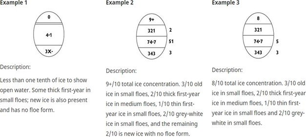
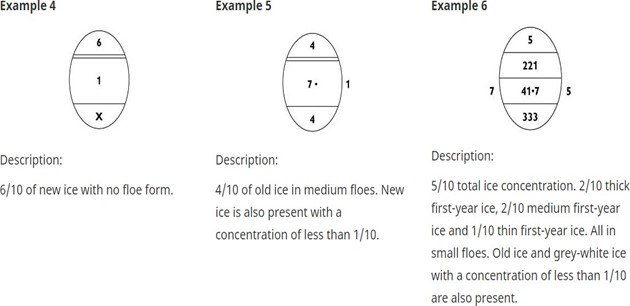
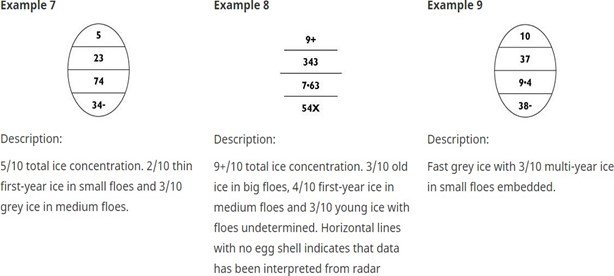
The basic data concerning concentrations, stages of development (age) and form (floe size) of ice are contained in a simple oval form. A maximum of three ice types is described within the oval. This oval and the coding associated with it, are referred to as the "Egg Code". To indicate ice observations interpreted from radar imagery, the oval shall be omitted.
In the following figures and tables where ranges are shown for thickness, floe sizes or other dimensions, a report coinciding with the end point of a range shall be coded as the higher value.
The following is a summary diagram of the Egg Code. This code conforms to international convention and shall be used in coding all visual sea ice and lake ice observations without exception.
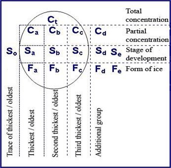
The symbols Ca Cb Cc and Fa Fb Fc correspond to Sa Sb Sc respectively.
There are some minor additions to the egg code symbology that are Canadian practice. In Canada, to enable the reporting of additional ice classes, especially during freeze-up and break-up, Cd Sd and Fe can be used. This should not be a common occurrence.
Concentration (C)
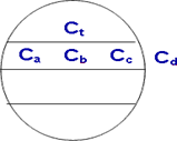
Total concentration (Ct) of ice in the area reported in tenths and partial concentrations of thickest (Ca), second thickest (Cb), third thickest (Cc) and fourth thickest (Cd) ice in tenths.
Notes:
Stage of Development (S)

Stage of development of thickest (So), second thickest (Sa), third thickest (Sb) and fourth thickest (Sc) ice and the thinner ice types Sd and Se, of which the concentrations are reported by Ca Cb Cc Cd respectively.
Notes:
Coding for Sea-Ice Stages of Development (So Sa Sb Sc Sd Se)
| Description | Thickness | Code |
|---|---|---|
| New ice | < 10 centimetres | 1 |
| Nilas, Ice rind | < 10 centimetres | 2 |
| Young Ice | 10 - 30 centimetres | 3 |
| Grey Ice | 10 - 15 centimetres | 4 |
| Grey-white ice | 15 - 30 centimetres | 5 |
| First-year ice | >= 30 centimetres | 6 |
| Thin first-year ice | 30 - 70 centimetres | 7 |
| First stage thin first-year | 30 - 50 centimetres | 8 |
| Second stage thin first-year | 50 - 70 centimetres | 9 |
| Medium first-year ice | 70 - 120 centimetres | 1· |
| Thick first-year ice | > 120 centimetres | 4· |
| Old ice | - | 7· |
| Second-year ice | - | 8· |
| Multi-year ice | - | 9· |
| Ice of land origin | - | |
| Undetermined or unknown | - | X· |
Notes:
Form of Ice (F)
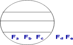
Floe Size corresponding to Sa Sb Sc Sd and Se (when Sd and Se are greater than a trace).
Notes:
Coding for Forms of Ice (Fa Fb Fc Fd Fe)
| Description | Width | Code |
|---|---|---|
| Pancake ice | - | 0 |
| Small ice cake, brash ice, agglomerated brash | < 2 metres | 1 |
| Ice cake | 2 - 20 metres | 2 |
| Small floe | 20 - 100 metres | 3 |
| Medium floe | 100 - 500 metres | 4 |
| Big floe | 500 - 2,000 metres | 5 |
| Vast floe | 2 - 10 kilometres | 6 |
| Giant floe | > 10 kilometres | 7 |
| Fast ice | - | 8 |
| Icebergs, growlers or floebergs | - | 9 |
| Undetermined, unknown or no form | - | X |
Notes:
Coding and Symbology for Strips and Patches
The symbol, placed at the bottom of the oval in the section reserved for Form of Ice, indicates that the ice is in strips and patches; the concentration within the strips and patches is represented by C.
When strips and patches are observed in open-water areas, the symbol shall be placed to denote the position of the strips and patches. If the ice in the strips and patches is of the same composition as that inside an adjacent ice edge, no oval is required. If the ice in the strips and patches is of a different composition, an oval shall be used with an arrow or arrow(s) to the strips-and-patches symbol(s). To avoid confusion, the strip symbol must be included with the total concentration.
In an area where the ice is arranged in strips and patches and the ice floes are medium or greater, the floe size shall be indicated by using two ovals. The floe sizes are indicated as normal in the first oval, with the symbol placed between the first and second ovals. The symbol is repeated in the second oval beside the total concentration of the strips and patches.
An alternate way of reporting the same situation as above:
In an area where the ice is arranged in strips and patches and the ice floes are medium or greater, the floe sizes shall be indicated as normal. Both the total concentration and the concentration within the strips will be placed in the space reserved for Ct, with the symbol between them. When this option is used, Ca Cb Cc and possibly Cd refer to the total concentration and not the concentration within the strips. For example, Ct can be reported as 29 meaning the total concentration is 2 tenths with strips of 9 tenths and the partial concentration(s) shall equal 2 tenths.
In an area of ice where some thicker ice type(s) is (are) embedded as strips and patches, these shall be indicated by the use of two ovals. The overall partial concentrations of the ice types are indicated in the first oval and the concentrations within the strips and patches are indicated in the second oval. The symbol shall be placed between the two ovals and along with the total concentration in the second oval.
Coding for Brash
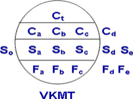
If 1 tenth or more of brash is present, it will always be Ca.
If brash is present, Sa will always be a dash (-), otherwise the normal table is to be used. Brash is already indicated in the table as 1, therefore Fa= 1 confirms the dash (-) for Sa. Four digits (VKMT) shall be added below the oval to indicate the thickness concentration breakdown of the brash that is present. Table 3.4 (below) shows the thickness Categories for agglomerated brash. The breakdown shall be entered going from right (T) to left (V). In the case where there is no thickness for thin but there are entries for medium, thick and very thick a zero (0) shall be placed in the thin column. This also holds true for medium (M) and thick (K) regardless of the combination.
Thickness Categories for Brash (VKMT)
| Description | Thickness |
|---|---|
| Very Thick (V) | > 4 metres |
| Thick (K) | > 2 - 4 metres |
| Medium (M) | 1 - 2 metres |
| Thin (T) | < 1 metre |
4.7 Examples of the Use of the Egg Code Various Ice Type and Concentration Combinations
Various Ice Type and Concentration Combinations
Strips and Patches
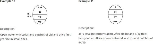
Below are hypothetical examples of how the Egg Code might be applied to various ice type and concentration combinations. Refer to "MANUAL OF STANDARD PROCEDURES FOR OBSERVING AND REPORTING ICE CONDITIONS (MANICE)" for detailed real-world examples.
| Example | Total Concentration (Ct) | Partial Concentrations (Ca, Cb, Cc, Cd) | Stages of Development (Sa, Sb, Sc, Sd, Se) | Floe Sizes (Fa, Fb, Fc, Fd, Fe) | Notes |
|---|---|---|---|---|---|
| Example 1: Uniform Ice | 8/10 | Ca: 8/10 | Sa: 7 (Thin First-Year Ice) | Fa: 4 (Medium Floe) | Single ice type, no additional partial concentrations indicated. |
| Example 2: Mixed Ice with Open Water | 6/10 | Ca: 4/10, Cb: 2/10 | Sa: 4· (Thick First-Year Ice), Sb: 1 (New Ice) | Fa: 5 (Big Floe), Fb: X (No Form) | Remaining 4/10 is Open Water, not explicitly coded. |
| Example 3: Strips and Patches | 2/10 (Total), 9/10 (Within Strips) | Ca: 2/10 | Sa: 9· (Multi-Year Ice) | Fa: 6 (Vast Floe) | Uses alternate reporting with symbol between total and strip concentration. |
| Example 4: Brash Ice | 3/10 | Ca: 3/10 | Sa: - (Brash) | Fa: 1 (Brash Ice) | VKMT: 1020 (Very Thick: 1, Thick: 0, Medium: 2, Thin: 0) |
CAUTION:
REFER TO THE PUBLICATION "MANUAL OF STANDARD PROCEDURES FOR OBSERVING AND REPORTING ICE CONDITIONS (MANICE) " FOR OTHER EXAMPLES AND CALCULATIONS
4.8 Vessel ice class rating
| Classification society | 10-15 cm | 15-30 cm | 30-50 cm | over 50 cm (Extremely difficult ice conditions) |
|---|---|---|---|---|
| Finland / Sweden | Category II | IC | IB | IA, IA Super |
| Russian Marine Register (issue 1995) | L4 | L3 | L2 | L1, UL |
| Russian Marine Register (issue 1999) | LU1 | LU2 | LU3 | LU4, LU5 |
| Russian Marine Register (issue 2008) | Ice 1 | Ice 2 | Ice 3 | Arc 4, Arc 5 |
| American Navigation Bureau | D0 | IC | IB | IA, IAA |
| Bureau Veritas | ID | IC | IB | IA, IA SUPER |
| CASPPR, 1972 | E | D | C | B, A |
| China Classification Bureau | B | B3 | B2 | B1, B1* |
| Det Norske Veritas | ICE-C | ICE-1C | ICE-1B | ICE-1A, ICE-1A* |
| Germanischer Lloyd | E | E1 | E2 | E3, E4 |
| Korean Marine Register | IS4 | IS3 | IS2 | IS1, ISS |
| Lloyd Register | 1D | 1C | 1B | 1A, 1AS |
| Nippon Kaiji Kyokai | ID | IC | IB | IA, IA Super |
| Italian Register | ID | IC | IB | IA, IAS |